
Photo courtesy Lake Michigan Biological Station, Illinois Natural History Survey.


Photo courtesy Lake Michigan Biological Station, Illinois Natural History Survey.
Coastal erosion is an issue that has long plagued Great Lakes shorelines. Erosion along the Illinois Lake Michigan coast is influenced by a variety of hydrodynamic processes that operate within the littoral (nearshore) zone resulting in problematic habitat loss, beach degradation and property damage. A variety of mitigation techniques have been implemented along the Illinois coast of Lake Michigan in recent years to reduce or halt the movement of sand from beaches, thereby preserving shoreline habitats and property/infrastructure.

Traditional erosion mitigation techniques have generally involved the installation of emergent hard structures (e.g. breakwaters, bulkheads and groins), which are designed to interrupt littoral processes and stop the movement of sand. Not only do these structures fragment the littoral zone and cause localized sand starvation at their downstream end, but they also disrupt the aesthetics of the coast. Unsurprisingly, they tend to be viewed as undesirable mitigation tools by many property owners and beachgoers. Submerged “reef-style” breakwaters may provide a viable, nature-based solution for shoreline protection and ecological enhancement that mimics natural shoal (shallow place in a body of water) features while allowing for some level of littoral processes to continue.
The U.S. Army Corps of Engineers constructed three parallel, submerged breakwaters (the “Rubble Ridges”) in 2021 as part of the Great Lakes Restoration Initiative’s Healthy Port Futures Program to test the effectiveness of small block sizes as an evolving (i.e., more natural) shoreline protection tool (as opposed to traditional emergent, large-block breakwaters). The Rubble Ridge site is located within Illinois Beach State Park, which contains the last remaining natural beach shorelines along Illinois’ Lake Michigan coast. The ridge-and-swale terrain here also contains many acres of valuable wetland habitat. In order to protect this valuable habitat and shoreline, the Rubble Ridges are located in shallow water (8 to 12 feet deep), approximately 300 feet from the shoreline. The top of the ridges is only 3 to 4 feet below the surface of the water and the ridges are approximately 25 feet apart, making it challenging to navigate over and between the structures.

The Illinois State Geological Survey (ISGS) and the Illinois Natural History Survey (INHS) have been monitoring post-construction morphodynamics (the study of landscape changes due to erosion and sedimentation) and aquatic fauna at the site, with operations based out of the Lake Michigan Biological Station and the North Point Marina Coastal Geology office located at the Illinois Beach State Park. The scientists have had to be creative with their survey design, as the orientation and location of the Rubble Ridges limits the use of traditional monitoring techniques around the structures, which are typically deployed from small boats. ISGS scientists have been using highly accurate/precise GPS equipment and sonar devices to determine the movement of the structures (i.e., blocks of stone) themselves, and the surrounding sandy lake-bottom elevation. INHS scientists have been conducting monthly surveys to characterize the ecological community by way of (1) SCUBA diving, (2) sampling sand for grain-size and benthic invertebrate analyses, and (3) setting gill nets for documenting fish utilization of the structure. Annual surveys of nearshore biological community dynamics conducted by INHS at a nearby location (Dead River off Illinois Beach State Park) since 2006 provide a biological baseline for pre- and post-construction habitat conditions. These data will be combined to provide an overall picture of the eco-geological impact of the Rubble Ridges on the nearshore and wetland habitat in Illinois Beach State Park.

Initial observations indicate that the Rubble Ridge structures show promise as erosion mitigation and aquatic habitat; however, continued monitoring is necessary to determine the long-term integrity and utility of the structure in Lake Michigan. Sand thus far has accumulated between the structure and the shoreline, suggesting a dampening of wave energy and shelter of sands within the structural lee (as a further shoreline buffer).

A variety of fish and invertebrate species have been observed at the Rubble Ridges during initial surveys, indicating that the structure is providing habitat for aquatic fauna. The most abundant fish observed within the structure is the non-native, but important prey fish, the round goby, with densities of fish approaching 50 round goby per meter squared on the reef during the summer months. INHS scientists used custom-built camera frames to determine round goby densities on the reef using a time-lapse underwater camera, creating a valuable and rare dataset of images for comparison in the future.

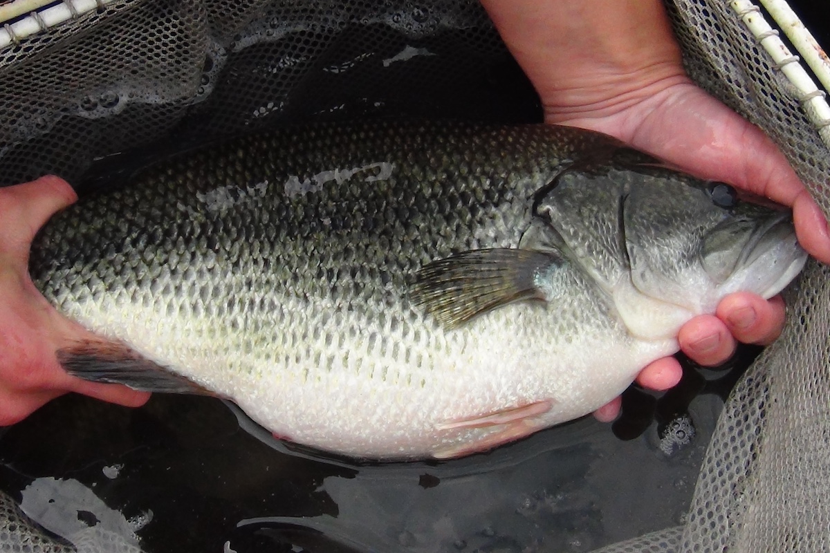
Many other fish have been observed on the Rubble Ridges as well, including the Illinois state-threatened longnose sucker, smallmouth bass, alewife, Coho and Chinook salmon, and lake trout. The role that the Rubble Ridges plays in the life history of these large fish is not yet fully understood, as these species are known to utilize a large geographic area. INHS scientists are hoping to determine if large fish are using the Rubble Ridges as spawning or nursery habitat in the future.
Geological and ecological monitoring of the Rubble Ridges will continue for another two years, totaling five years of intensive monitoring data. The goal of this project is to not only understand the effects of the Rubble Ridges locally, but also determine other locations throughout the Great Lakes where submerged reef structures might be a viable option for shoreline protection and habitat creation.
Hillary Glandon is an aquatic ecologist with the Illinois Natural History Survey at the Lake Michigan Biological Station in Zion. She conducts research related to coastal resilience and aquatic ecology in the Great Lakes and beyond.
C. Robin Mattheus is a coastal geologist with the Illinois State Geological Survey. His research group focuses on active geological monitoring of Illinois shoreline environments, including those along Illinois Beach State Park, using precision surveying methods and a variety of sediment-sampling techniques. He works closely with the Chicago Park District, Illinois’ Coastal Management Program, and other coastal stakeholders to provide geospatial data for management applications.


Submit a question for the author