


Historically, bobcats (Lynx rufus) were widespread across prairie woodland complexes of the Midwest, though were considered rare throughout the Corn Belt region during the century (1840s–1940s) following European settlement. In 1977, the Illinois Department of Natural Resources (IDNR) listed bobcats as a state threatened species (17 Illinois Administrative Code 1010) following initial protection under the Wildlife Code (Public Act 77-1781, 520 Illinois Compiled Statutes 5/2.2). With restricted harvest for the following 20 years, bobcat sightings increased statewide through the 1990s. In 1999, bobcats were removed from the Illinois state threatened species list and the first harvest season in more than 40 years was implemented in 2015. Despite the recovery of bobcat populations across Illinois, previous research has been limited to southern Illinois where the largest area of suitable habitat exists. Thus, the need for quantitative information on bobcat population ecology in other regions of the state is timely.
Researchers at Western Illinois University (WIU) initiated a multi-year study to evaluate home range use and the utility of camera traps for estimating bobcat abundance (2015−2017; Phase 1), and further development of camera survey protocols and evaluating annual/seasonal survival rates (2017−2019; Phase 2) of bobcats across west-central Illinois. Development of camera survey protocols incorporates information on home range use, rates of bobcat capture/recapture rates for varying spatial arrays of camera traps, and habitat data gathered from GPS locations from previously captured animals. More specifically, researchers use spatial capture-recapture (SCR) designs to identify individual bobcats based on unique spot patterns (which are like fingerprints and different for every bobcat) within a camera survey grid. The physical location (i.e., GPS coordinates) of cameras and numbers of capture/recapture events across multiple camera stations are used to create encounter histories of bobcats that walk in front of cameras.
Researchers use this information in combination with locations of radio-collared individuals to generate reliable estimates of bobcat density. Use of remote cameras is less invasive, labor intensive and costly than other long-term census techniques (trapping and collaring all bobcats in an area).
Bobcat Captures and Camera Surveys
Upon capture, researchers chemically immobilize bobcats prior to handling to ensure safety to field capture crews and study animals. Following sedation, researchers fit each animal with a mortality-sensing very high frequency or global positioning system radiocollar. Throughout processing events, vital rates (e.g., heart rate, temperature, pulse, respiration) are monitored every 5 minutes and morphological data (e.g., body weight, body length, chest/neck circumference) collected. Researchers also estimate age (based on patterns of wear and staining on teeth), assess reproductive and overall body condition, and collect blood and ectoparasites (e.g., ticks and fleas) from captured bobcats.

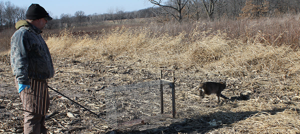
Bobcats are captured using nonlethal (cage and foothold) traps. In addition, WIU researchers rely heavily on local trappers to ensure that the desired number of bobcats are captured each year. To date, 68 percent (n=26) of WIUs research animals have been captured by local fur trappers across the study site, which is predominantly (99 percent) in private ownership. Thus, gaining access to private land and building relationships with local landowners and trappers throughout our primary study area (Fulton, McDonough, Schuyler and Hancock counties) is essential. The project would not be successful without the support of local landowners and continued involvement of trappers. Researchers at WIU are especially interested in continuing to work with private landowners and trappers throughout the study site (particularly Fulton County) during the 2018 trapping season, and will compensate trappers $150 for each bobcat they live-capture for future use in ongoing bobcat research.
After a bobcat is radio-collared, researchers use standard telemetry techniques (e.g., fixed-wing aircraft, truck-mounted and hand-held antennas) to monitor weekly movement and survival status. Researchers then enter animal locations into a Geographic Information System (GIS) to determine home range size and spatial activity patterns, which aids in the development, evaluation and future use of non-invasive camera surveys to monitor bobcat abundance across the state.
Cameras are deployed systematically by subdividing the four counties into a series of 3.5 square mile grids. Researchers attempt to deploy cameras as close to grid centers as possible to maintain consistent spacing between consecutive camera stations. Camera stations are deployed in grids that contain ≥ 50 percent forested cover (i.e., bobcat habitat) for 8−10 weeks throughout the breeding season (1 November to 30 April) to maximize the probability of detecting bobcats; camera stations remain in the same location over the duration of the camera survey period.
Preliminary Results
To date, researchers have collared 38 (20 males, 18 females) bobcats, of which they are currently monitoring movement and survival status of 11 GPS and 14 VHF-collared individuals. Home range size for males and females average 46 mi2 and 8 mi2, respectively, though range from 3−80 mi2. Through February 2018, researchers have documented eight bobcat deaths; vehicle collisions are the leading cause of mortality and have accounted for four (50 percent) mortality events. Remaining deaths have been attributed to harvest (n=3; [1 legal, 1 illegal, 1 incidental harvest]) and capture-related factors (n=1). Estimated annual survival is 51 percent. Bobcat survival monitoring is ongoing through June 2019 and will evaluate potential effects of sex, age, and habitat variables on seasonal and annual survival rates.
During Phase 1, more than 600,000 images were collected from 140 camera stations deployed across breeding and kitten-rearing (1 May to 31 October) seasons from November 2015 to April 2017. During Phase 2, approximately 220 cameras were deployed during winter 2018, and will remain active through March 2018. Since 2015, approximately 360 camera stations (i.e., 720 total cameras) have been deployed throughout the four-county region. Bobcat density estimates were generated using 50 camera stations deployed over a 77-day period from 1 February–18 April 2017. Mean operational time of cameras was 52 days, though varied from 32 to 67 days. In total, 23 uniquely identifiable bobcats were captured 115 times and recaptured 92 times. Bobcats were photographed at 36 of 50 (72 percent) camera stations. The bobcat density estimate was 1.44 individuals per 100 km2, though ranged from 1.07 to 1.90 bobcats/100 km2 (~31 mi2).
Phase 2 work is ongoing and final project results will be available during summer 2019. In the interim, quarterly project updates will be available starting in May 2018; information can be found on the
WIU Department of Biology website. Feel free to contact Dr. Jacques (309-298-2155) cn-jacques@wiu.edu, or Ed Davis (919-548-5196), with questions or comments regarding ongoing bobcat research. Funding support is provided by Federal Aid in Wildlife Restoration administered through the IDNR, Furbearer’s Unlimited, Illinois Bobcat Foundation, Whitetails Unlimited and Illinois Humane.
Ed Davis is a graduate student at Western Illinois University (WIU) working under the direction of Dr. Christopher Jacques. His MS research focuses on bobcat density estimation with built in occupancy modeling, habitat modelling of GPS collared bobcats, and survival and cause-specific mortality of collared bobcats in west-central Illinois. Davis started during summer 2017 and his research will build off previous work conducted from 2015−2017.
Tim Swearingen is a graduate student at WIU working under the direction of Dr. Christopher Jacques. His MS research focuses on evaluating the efficacy of camera traps (concurrent with live trapping and radio-collaring) to estimate bobcat abundance across fragmented landscapes of west-central Illinois. Swearingen started in the summer of 2015 and his research will identify relationships between camera density, variation in habitat types and bobcat detection probabilities.
Share this Article
Subscribe to our Newsletter
Explore Our Family of Websites


Submit a question for the author
Question: We feed feral cats and paid to have 2 females fixed. My question is, one cat who comes almost everyday looks like a bobcat (larger than a regular cat, has markings of a bobcat but has a long tail with dark rings around the tail. We can’t pet him but he will come within 3 feet of us and eats the cat food and drinks the water we provide. Yesterday we had a really odd cat that didn’t have a tail, just white fluff on its backside and was actually a yellow tiger striped cat but as big as a bobcat. Wondering if it could have bred with a bobcat?